Tomamae, Hokkaido
Tomamae
苫前町 | |
|---|---|
 Sunset over Tomamae | |
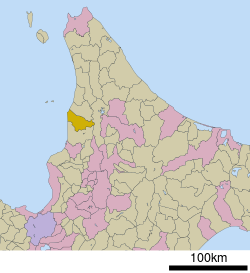
 Location of Tomamae in Hokkaido (Rumoi Subprefecture) | |
 | |
| Coordinates: 44°18′32″N 141°39′11″E / 44.30889°N 141.65306°E | |
| Country | Japan |
| Region | Hokkaido |
| Prefecture | Hokkaido (Rumoi Subprefecture) |
| District | Tomamae |
| Area | |
• Total | 454.60 km2 (175.52 sq mi) |
| Population (January 31, 2025) | |
• Total | 2,659 |
| • Density | 5.8/km2 (15/sq mi) |
| Time zone | UTC+09:00 (JST) |
| City hall address | 37-1 Asahi, Tomamae-cho, Tomamae-gun, Hokkaido 078-3792 |
| Website | Official website |
| Symbols | |
| Flower | Corydalis ambigua |
| Tree | Japanese rowan |


Tomamae (苫前町, Tomamae-chō) is a town located in Rumoi Subprefecture, Hokkaido, Japan. As of 31 December 2024[update], the town had an estimated population of 2,659 in 1,428 households, and a population density of 5.8 people per km2.[1] The total area of the town is 454.60 km2 (175.52 sq mi).
Geography
[edit]Tomamae is located in the part of Rumoi jurisdiction in northern Hokkaido, facing the Sea of Japan to the west.
Neighbouring municipalities
[edit]Climate
[edit]Tomamae has a Humid continental climate (Köppen Dfb) characterized by cold summers and cold winters with heavy snowfall. The average annual temperature in Tomamae is 6.8 °C. The average annual rainfall is 1207 mm with September as the wettest month. The temperatures are highest on average in August, at around 20.5 °C, and lowest in January, at around -6.5 °C.[2]
Demographics
[edit]Per Japanese census data, the population of Tomamae is as shown below. The town is in a long period of sustained population loss.
| Year | Pop. | ±% |
|---|---|---|
| 1940 | 8,101 | — |
| 1950 | 11,212 | +38.4% |
| 1960 | 10,898 | −2.8% |
| 1970 | 8,544 | −21.6% |
| 1980 | 6,528 | −23.6% |
| 1990 | 5,251 | −19.6% |
| 2000 | 4,645 | −11.5% |
| 2010 | 3,657 | −21.3% |
| 2020 | 2,936 | −19.7% |
History
[edit]The area of Tomamae has been inhabited since the Jōmon period, and was the site of a kotan was built by the Ainu people. When Matsumae Domain advanced into the area in the Keichō era (1596-1615), a trading settlement was built. In 1786, the Tomamae Shrine, a Shinto shrine was constructed. The village of Tomamae was created in 1880, and separated from Haboro in 1894. It was raised to town status on October 1, 1948.
Government
[edit]Tomamae has a mayor-council form of government with a directly elected mayor and a unicameral town council of eight members. Tomamae, as part of Rumoi sub-prefecture, contributes one member to the Hokkaidō Prefectural Assembly. In terms of national politics, the town is part of the Hokkaidō 10th district of the lower house of the Diet of Japan.
Economy
[edit]The local economy of Tomamae is centered on commercial fishing and agriculture. The town also operates it own wind power station, producing (in 2024) a surplus of 575% more power than is consumed in the town and providing a substantial incoming source to the town government.[1]
Education
[edit]Tomamae has two public elementary schools and one public junior high school operated by the town government, and one public high school operated by the Hokkaidō Board of Education.
Transportation
[edit]Railways
[edit]After the closure of the Japan National Railway Teshio Line in 1987, the town has not had any passenger rail service.
Highways
[edit]Mascot
[edit]
Tomamae's mascot is Kumada Tomao (くまだ とまお), better known as Tomao-kun (とまおくん). He is a 7-year-old brown bear cub. He wears a hat that has two badges (a windmill badge and a badge dedicated to agricultural and seafood products).[3]
See also
[edit]References
[edit]- ^ a b "Tomamae Town official statistics" (in Japanese). Japan.
- ^ Tomamae climate: Average Temperature, weather by month
- ^ "くまだ とまお (北海道)". Yuru-Chara Grand Prix.
External links
[edit] Media related to Tomamae, Hokkaidō at Wikimedia Commons
- Official Website (in Japanese)


